For the data acquisition DPP uses the open-source Database System OpenAtlas (openatlas.eu). It
stores its information based on the CIDOC-CRM (www.cidoc-crm.org) and therefore is
from a conceptual point of view highly compatible and sustainable on an international level.
Regarding the technological framework the data is primarily stored in a PostgreSQL and PostGIS
database and fulfils state of the art technical standards. Whenever records can
be spatially located (E.g. the location of a physical thing or, for example, the site where an event took place) they are geo-referenced.
Next to the coordinates of locations also other geometries are stored. They can be for example polygons
that mark the area of a certain settlement or polylines that represent roads etc. They and can be accessed, displayed
or edited with every GIS-Software that supports PostGIS or other common standards like WKT or Geojson.
OpenAtlas links all the interconnections between the stored entities. For instance it is possible to map
(in a conceptual as well as geographical meaning) the places where e.g. King Arnulf of Carinthia was present
during his reign and for which reasons he was there and which role he played in the respective events.
If for example a donation of a manor located in Carinthia is carried out at the court in Regensburg/Ratisbona you
can connect the King to the place where this happened and also to the place that gets donated as well as to other involved
actors like the new owner and the witnesses, too. Next to this the sources that refer to these events are also interconnected
as well as temporal information on when the recorded events occurred. Also files (images, documents) and external
references (e.g. Wikipedia entries) can be recorded and linked.
After the project’s data acquisition is finished, the gathered information will be provided as open-data in various
formats. The primary data will be available for download and an endpoint for linked open data will be provided.
The intention is to use these data for further analyses and visualisations mainly aiming at GIS- and network analyses.
The software developed within the project will be released as open-source tools and we hope it can prove useful for others too.
The projects website will furthermore host an online application to search, query, export, browse and visualize
the data via a geographical map interface (see Geocommunication). There the data can be explored easily without
other technical tools and without downloading anything.
Any comments and suggestions on these examples of our work are highly welcome.
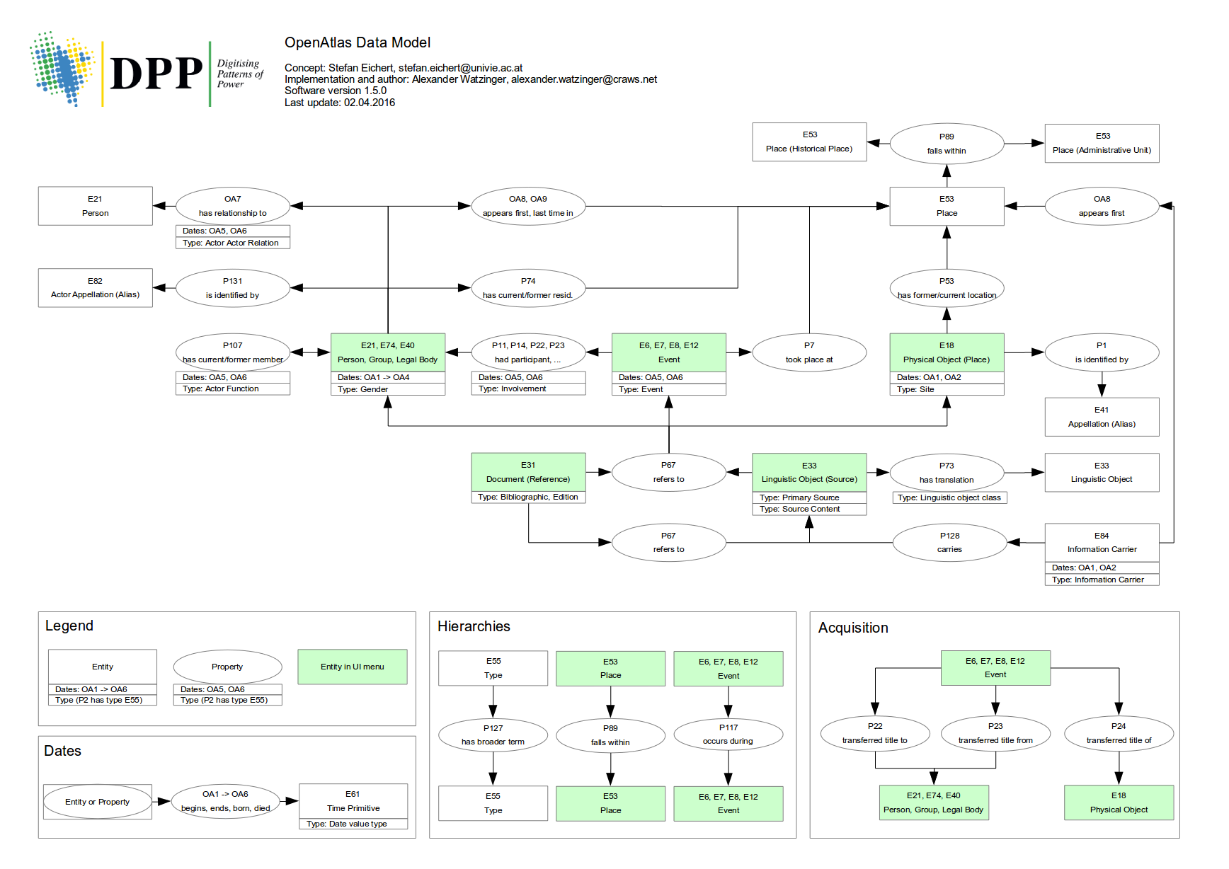
OpenAtlas database Schema (S. Eichert, A. Watzinger, 2018)